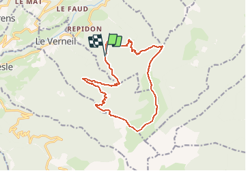
Trail Walking La Table - Route traversée des grand chats option chapotet - Photo

Route traversée des grand chats option chapotet

© OpenStreetMap contributors
Length
Length
16 km
Max alt
Max alt
2069 m
Uphill gradient
Uphill gradient
1075 m
Km-Effort
Km-Effort  
30 km
Min alt
Min alt
1141 m
Downhill gradient
Downhill gradient
1068 m
Boucle
Boucle
Yes
Creation date :
2019-10-08 21:33:51.713
Updated on :
2020-06-24 17:33:34.312

(0 Reviews)

Walking
Walking
5h46
Difficulty : Very difficult

Scan this QR Code to open this trail in the SityTrail application

FREE GPS app for hiking

Logo SityTrail SityTrail

IGN / Geographical institutes

Download SityTrail from the App Store Download SityTrail from Google Play

Logo SityTrail SityTrail World

The world is yours!

Download SityTrail from the App Store Download SityTrail from Google Play Download SityTrail on Huawei AppGallery

About

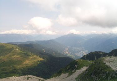
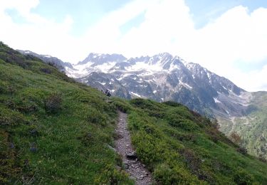
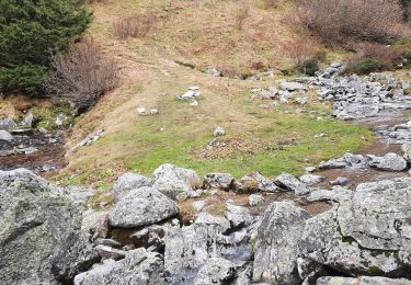
Trail Walking of 16 km to be discovered at Auvergne-Rhône-Alpes, Savoy, La Table. This trail is proposed by Parodie69.

Description

départ du prévieux

Elevation profile

Points of interest

Point of interest La Table - N°1 - Photo
Parodie69
LA TABLE 
Point of interest La Table - N°3 - Photo
Parodie69
LA TABLE 
Point of interest Bourget-en-Huile - N°4 - Photo
Parodie69
BOURGET-EN-HUILE 
Point of interest La Table - N°5 - Photo
Parodie69
LA TABLE 
Point of interest Saint-Alban-d'Hurtières - N°6 - Photo
Parodie69
SAINT-ALBAN-D'HURTIÈRES 
Point of interest Le Verneil - N°6bis - Photo
Parodie69
LE VERNEIL 
Point of interest Presle - N°7 - Photo
Parodie69
PRESLE 
Point of interest Presle - N°8 - Photo
Parodie69
PRESLE 
Point of interest Le Verneil - N°9 - Photo
Parodie69
LE VERNEIL 

Positioning

Country:
France
Region :
Auvergne-Rhône-Alpes
Department/Province :
Savoy
Municipality :
La Table
Location:
Unknown
Start:(UTM)
280422 ; 5037680 (32T) N.

Trails nearby

Trail Walking Arvillard - Les Grands Moulins 2495m - Photo
Walking
tracegps

Walking

Difficult
(1)
Arvillard, Auvergne-Rhône-Alpes, Savoy, France
9 km | 20 km-effort
5h 0min
Yes
Trail Walking Saint-Alban-d'Hurtières - Col Clampet, Le Grand Chat, Col d'alarmant  - Photo
Walking
Zasa

Walking

Easy
Saint-Alban-d'Hurtières, Auvergne-Rhône-Alpes, Savoy, France
8.4 km | 15.5 km-effort
3h 15min
Yes
Trail Walking Presle - tour du chapoté  - Photo
Walking
Youcef Atallah

Walking

Very difficult
Presle, Auvergne-Rhône-Alpes, Savoy, France
13.2 km | 24 km-effort
3h 50min
Yes
Trail Walking Presle - Le chapotet au départ de Prodin - Photo
Walking
Zasa

Walking

Medium
Presle, Auvergne-Rhône-Alpes, Savoy, France
12.1 km | 23 km-effort
5h 0min
Yes
Trail Walking Saint-Pierre-de-Belleville - poste optique Rognaix lac vert Rognaix 2 - Photo
Walking
jibebouvier

Walking

Difficult
Saint-Pierre-de-Belleville, Auvergne-Rhône-Alpes, Savoy, France
16.8 km | 38 km-effort
6h 4min
Yes
Trail Walking Presle - 2023-06-15 Prodin -Col de la Perche en boucle  - Photo
Walking
patpounet73

Walking

Medium
Presle, Auvergne-Rhône-Alpes, Savoy, France
12 km | 22 km-effort
4h 34min
Yes
Trail Walking La Trinité - les Tours de Montmayeur  - Photo
Walking
GuyVachet

Walking

Difficult
La Trinité, Auvergne-Rhône-Alpes, Savoy, France
16.3 km | 24 km-effort
6h 27min
No
Trail Walking La Trinité - Les Tours de Montmayeur au départ de la Trinité via col de Cochette - Photo
Walking
ranchoup

Walking

Easy
La Trinité, Auvergne-Rhône-Alpes, Savoy, France
12.9 km | 20 km-effort
4h 44min
Yes
Trail Walking Presle - crete du Gargoton  - Photo
Walking
doumeherve

Walking

Medium
Presle, Auvergne-Rhône-Alpes, Savoy, France
8.8 km | 20 km-effort
3h 26min
Yes


Close
My subscriptions